Gas station nearby محطة النور - المره الغربية
Qatar
Gas station nearby محطة النور - المره الغربية
محطة النور - المره الغربية
Al Rayyan Road, Doha, QA Qatar
contacts phone
:
+974
Latitude:
25.2398244
, Longitude:
51.430524
larger map & directions
read more
nearest Gas station
1.806 km
WOQOD
Ar-Rayyan
Gas station
read more
2.496 km
ATIAF PROJECTS COMPANY
424, Al Azizia Street, Doha
Gas station
read more
3.717 km
محطة بترول وقود
Ar-Rayyan
Gas station
read more
5.225 km
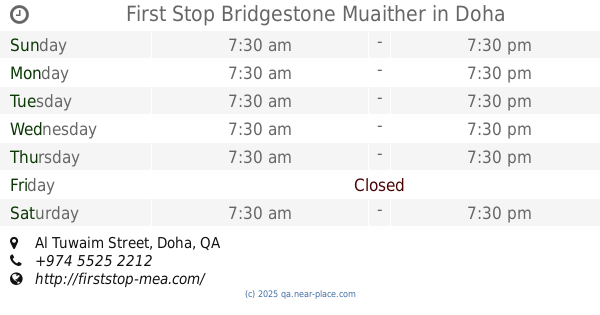
First Stop Bridgestone Muaither
Al Tuwaim Street, Doha
Gas station
read more
5.763 km
Al Waab Petrol Station
Al Waab Street, Doha
Gas station
read more
6.873 km
Al Mana Petrol Station
Doha
Gas station
read more
9.073 km
Woqood Petrol Station
Doha
Gas station
read more
9.817 km
Woqod Mobile Petrol Station
Rawdat Al-Khail Street B Ring Road, Doha
Gas station
read more
10.579 km
Multiplex babyshop pump stop
Al Rayyan Road, Doha
Gas station
read more
10.89 km
Gasolinera-lavadero
Doha
Gas station
read more
11.337 km
Woqod garaffa
Ar-Rayyan
Gas station
read more
11.484 km
Teyseer Petrol Station
#44 Najma Street.، الدوحة
Gas station
read more
11.632 km
Waqood Petrol Station Bank Street
Doha
Gas station
read more
11.639 km
Waqod
Doha
Gas station
read more
12.136 km
WOQOD mobile fuel station Izghawa
Izghawa, Ar-Rayyan
Gas station
read more
12.39 km
محطة وقود قطر
Al Duhail North, Doha
Gas station
read more
12.401 km
Duhail Gas Station
Doha
Gas station
read more
12.481 km
Duhail Petrol Station
Doha
Gas station
read more
12.895 km
Woqod Petrol Station Umm Ghuwailina
Doha
Gas station
read more
12.902 km
Woqod petrol station
Doha
Gas station
read more
12.963 km
West Bay Petrol Station
Doha
Gas station
read more
12.976 km
Teyseer Hewar Petrol & Service Station
Area # 48, C-Ring Road, pbox 1556, Doha
Gas station
read more
12.995 km
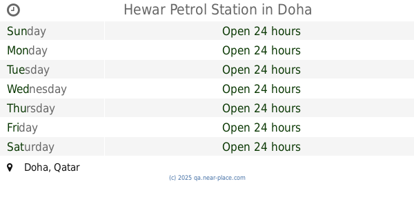
Hewar Petrol Station
Doha
Gas station
read more
13.185 km
University Petrol station
Doha
Gas station
read more
14.572 km
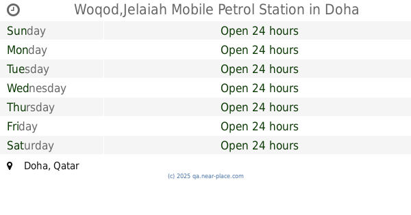
Woqod,Jelaiah Mobile Petrol Station
Doha
Gas station
read more
📑
all categories
Accounting
Administrative area level 1
Airport
Amusement park
Art gallery
Atm
Bakery
Bank
Bar
Beauty salon
Bicycle store
Book store
Bowling alley
Bus station
Cafe
Campground
Car dealer
Car rental
Car repair
Car wash
Cemetery
Church
City hall
Clothing store
Convenience store
Country
Courthouse
Dentist
Department store
Doctor
Electrician
Electronics store
Embassy
Establishment
Finance
Fire station
Florist
Food
Furniture store
Gas station
General contractor
Grocery or supermarket
Gym
Hair care
Hardware store
Health
Home goods store
Hospital
Insurance agency
Jewelry store
Laundry
Lawyer
Library
Light rail station
Liquor store
Local government office
Locality
Locksmith
Lodging
Meal delivery
Meal takeaway
Mosque
Movie theater
Moving company
Museum
Natural feature
Neighborhood
Night club
Painter
Park
Parking
Pet store
Pharmacy
Physiotherapist
Place of worship
Plumber
Point of interest
Police
Post office
Premise
Real estate agency
Restaurant
Roofing contractor
Route
School
Shoe store
Shopping mall
Spa
Stadium
Storage
Store
Supermarket
Taxi stand
Transit station
Travel agency
University
Veterinary care
Zoo
sublocality level 1
↑