School nearby مدرسة البياان
Qatar
School nearby مدرسة البياان
مدرسة البياان
Izghawa, Ar-Rayyan, Qatar
Contacts phone
:
+974
Latitude:
25.3548944
, Longitude:
51.4304597
Larger map & directions
Read more
Nearest School
260 m
Awfaz Global School
Ar-Rayyan
School
Read more
274 m
مدرسة أوفاز الغرافة
Gharrafat Al Rayyan Street, Ar-Rayyan
School
Read more
364 m
Rainbow Nursery
Gharrafat Al Rayyan Street, Ar-Rayyan
School
Read more
527 m
Ibn Khaldoun Preparatory Independent School for Boys
Ar-Rayyan
School
Read more
886 m
مدرسة الوسيل الابتدائيه
Izghawa, Ar-Rayyan
School
Read more
1.095 km
مدرسة القديمة
Ar-Rayyan
School
Read more
1.19 km
Leapahead Nursery
Ar-Rayyan
School
Read more
1.222 km
Kindergarten Losail
Ar-Rayyan
School
Read more
1.248 km
Kindergarten Sama teach our children the love of learning
Izghawa, Ar-Rayyan
School
Read more
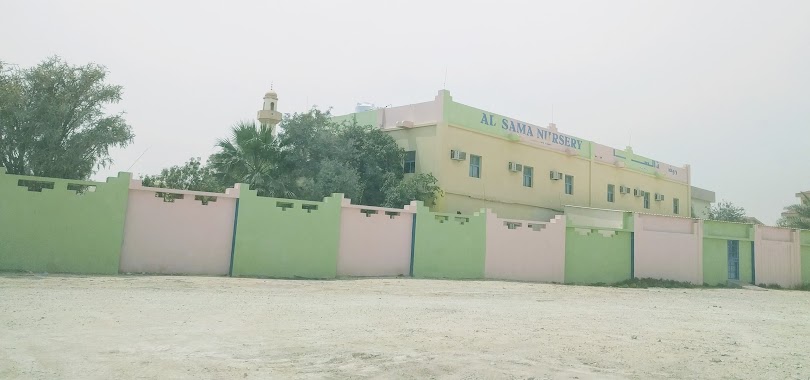
1.26 km
Al Sama Nursery
Izghawa, Ar-Rayyan
School
Read more
1.274 km
مركز الاتقان للقرآن وعلومه
Gharrafat Al Rayyan Street, Ar-Rayyan
School
Read more
1.429 km
Kidz International Pre-School (KIPS)
25.3488, 51.4432, Doha
School
Read more
1.436 km
Kids International Pre-School
Ar-Rayyan
School
Read more
1.505 km
Al Khawarazmi KG
Ar-Rayyan
School
Read more
1.565 km
The Toddler House British Nursery
Zekreet Street, Izghawa, Kharaitiyat, Doha
School
Read more
1.571 km
Al-Manar International School
Izghawa, Ar-Rayyan
School
Read more
1.603 km
الخوارزمي ب المستقلة للبنات
Ar-Rayyan
School
Read more
1.89 km
Oxford School
Ar-Rayyan
School
Read more
1.947 km
Oxford English School, Doha, Qatar
Ar-Rayyan
School
Read more
2.008 km
Al Refaa School
Izghawa, Ar-Rayyan
School
Read more
2.123 km
مركز القادة التعليمي
Ar-Rayyan
School
Read more
2.381 km
أكاديمية رسما Rasma Academy
Al Maszhabiliya Street, Rayyan
School
Read more
2.382 km
Rasma Academy
Qatar
School
Read more
2.454 km
Barara Nursery
Al, Gharafa
School
Read more
2.541 km
Gulf English School
Al Gharrafa Street, Ar-Rayyan
School
Read more
📑
All categories
Accounting
Administrative area level 1
Airport
Amusement park
Art gallery
Atm
Bakery
Bank
Bar
Beauty salon
Bicycle store
Book store
Bowling alley
Bus station
Cafe
Campground
Car dealer
Car rental
Car repair
Car wash
Cemetery
Church
City hall
Clothing store
Convenience store
Country
Courthouse
Dentist
Department store
Doctor
Electrician
Electronics store
Embassy
Establishment
Finance
Fire station
Florist
Food
Furniture store
Gas station
General contractor
Grocery or supermarket
Gym
Hair care
Hardware store
Health
Home goods store
Hospital
Insurance agency
Jewelry store
Laundry
Lawyer
Library
Light rail station
Liquor store
Local government office
Locality
Locksmith
Lodging
Meal delivery
Meal takeaway
Mosque
Movie theater
Moving company
Museum
Natural feature
Neighborhood
Night club
Painter
Park
Parking
Pet store
Pharmacy
Physiotherapist
Place of worship
Plumber
Point of interest
Police
Post office
Premise
Real estate agency
Restaurant
Roofing contractor
Route
School
Shoe store
Shopping mall
Spa
Stadium
Storage
Store
Supermarket
Taxi stand
Transit station
Travel agency
University
Veterinary care
Zoo
sublocality level 1
↑